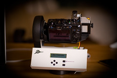
On Thursday, September 23 there will be a photo shoot for the 2nd Pittsburgh Gigapanorama – you are invited to participate. The details for Thursday are available here. For the whole story about the project keep reading.
 Gigapana-What? I promise this is not a scary disease or some fancy name for bed bug infestation – a gigopanorama is a giant panoramic photo. In most basic terms – lots of digital photos are stitched together to create a large panoramic photo. You can learn more about these photos and the technology behind the giga pan photos at Gigapan.org. Carnegie Mellon and Pittsburgh based DeepLocal are key partners in this project. Gigapan.org also has a huge gallery of other amazing photos to check out.

- Image by liber via Flickr
The First Pittsburgh Gigapanorama was created in October, 2009 from the roof of the US steel building. You can check out the photo here. The GigaPan.org website lets you navigate and zoom in on different parts of the photo. There is also an actual print out of this photo that has been displayed around the city – I had a chance to see it earlier this summer at the Sprout Fund Summer Social. It is a HUGE banner with amazing detail of the city. Continue reading

![Reblog this post [with Zemanta]](http://img.zemanta.com/reblog_c.png?x-id=fc292c24-cc1a-4bae-ac6f-15b1313cfc63)