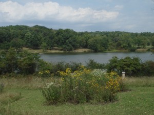
Most of the park is built around Keystone Lake; fishing and boating are permitted, and canoes and the like are rented out (check for the building near the northwest corner of the lake). Swimming is permitted in one section of the lake, and indeed, there is an extended lawn near the swimming area, as well as a concession stand and a large playground. This “beach” area tends to be rather crowded in the summer, though, so plan accordingly.
There aren’t many “trails” at Keystone; most of them are located near the Wetlands Observation Area. I suggest parking in the beach parking lot and crossing the street from there, but one can also park in a smaller lot further up the road, a lot that will provide access to the opposite end of the trail system. Admittedly, the trail system is rather confusing, because the intersections don’t coincide with those on the park map, and although the trails are blazed, the blazes are not marked on the map…
Actually, in this instance, I’d argue that simply walking around the lake, on the road and through fields and sidewalks, is a better way of enjoying the park. As odd as it sounds, walking through the campgrounds is rather entertaining; it helps that the Lakeside Trail, which connects the campground to the “smaller lot further up the road” I mentioned earlier, is a really cool, shady walk that’s littered with picnic tables that are great places to, um, picnic, or just to sit and stare mindlessly at the lake.
While you’re in the campground section, with cabins and yurts and all, keep a lookout for the stone lodge, which marks the trailhead for (guesses, anyone?) Stone Lodge Trail. The building itself is neat, for a start, and the trail is one of the better ones at Keystone.
Directions: From Rt. 22, look for Rt. 981 South; there are several ways to turn into the park from here. The most obvious is via Keystone Park Road, but one can also turn onto Flowers Road (which leads to Keystone Park Road); both will be left turns. When I went, a crucial section of Keystone Park Road was closed, necessitating a detour; if the road closures are still in effect when you read this, continue on Rt. 981 until you reach Slag Road (it’ll be on the left, after the parking lot for Loyalhanna Day Use Access). Slag Road will also lead directly into the park, albeit from a different direction; actually, this can be advantageous for first time visitors, because the park office will be the first in-park turn you encounter, so you can stop and pick up some maps if you haven’t already acquired them elsewhere.
From Rt. 30, look for Rt. 981 North; the turning roads will be the same, although they will obviously be right turns instead of lefts.
Also in the area…
The Loyalhanna Lake National Recreation Area is located off of Rt. 981, north of Rt. 22. If you have the time and are so inclined, it’s worth making the effort to visit. Unless you’re planning to fish or picnic, odds are the primary reason for visiting will be to see the dam; depending on your temperament, this will qualify as either worthy and fascinating or appallingly boring. I found it enjoyable enough, but hey, that’s me…
Directions: From Rt. 981 heading north from Rt. 22, look for the signs on your left. You’ll be looking for Bush Road, but it’s easier to look for signs for the park. Don’t be put off by the narrow, twisting road, but then, don’t be in a hurry either. For more details, or simply for your own peace of mind, it might be useful to take along a copy of the area map.

Thanks, going canoeing on July 4! not too far, traveling closer to home this year. Great map markings etc. have a great 4th!!!!!!!!!!!!!!!!!!!
PS We enjoyed the photo of the lake!!!!!!!!!!!!!!!!!!!!!!!!!!!!! The Lanucies!!!!!!!!!!!!!!!!!