Tag Archives: Orienteering

Map & Compass Orienteering in Frick Park – Dec. 1

Some of the most popular posts here on this blog have been about scavenger hunts – so we wanted to share this event from the Western PA Orienteering Club.

This Saturday, December 1, 2012 the Western PA Orienterring Club is headed to Frick Park for their last event of 2012.

Here are the details for the event from the Meet-up page:

For the first time, Frick Park has been mapped into a standardized Orienteering (the sport) format, using map symbols and conventions that are specific to that activity. The Western Pennsylvania Orienteering Club will host a meet on Saturday December 1, registration and starts can be anytime between 10 AM and 1 PM, and everybody must be finished by 2:30 PM (time when the courses officially close).

Orienteering is a outdoor recreational activity in which participants find checkpoints in the woods using solely a topographic map and a compass (no GPS, like in geocaching…). It can be either competitive (runners) or non-competitive (walkers). It is rain or shine. It is all ages (7 year olds and 90 year olds all welcome). It is all skills (beginners, intermediate, advanced). It is inexpensive ($5 for the map – group or family doing event together with just one map only pay $5 for the entire group. If a group has five people and sharing one map, it comes to $1/person).

The meet HQ will be setup in the small shelter at the bottom of the Ravine Trail, also known as “Lower Frick”. There is a parking lot for vehicles, reachable from Hutchinson Avenue when coming from S. Braddock Ave.

There is no mass-start. The starts are staggered two minutes apart so that participants don’t follow each other. Orienteering is a land navigational challenge, in which one selects the best and optimal route to from point A to point B, considering obstacles, climb, terrain, visual references.

This question comes pretty often, so here is the answer: “can I bring my dog?”… “yes you can, as long as it complies with city ordinances, such as being on a leash”

Beginner instruction is available on site by volunteers.

There will be four courses available:

  • The beginner course (White) will have a bird’s eye distance of about 2.5 km. All checkpoints are located along a trail or very accessible terrain.
  • The advanced beginner course (Yellow) will have a bird’s eye distance of 3.5 km. Checkpoints are visible from trail and there may be off-trail short travel to reach them.
  • The intermediate course (Orange)will have a bird’s eye distance of about 5 km, and will involve some bushwacking and off-trail navigation.
  • The advanced course (Red) will have a bird’s eye distance of about 7.5 km, and have checkpoints located in hard-to-find locations, and given the hills of Frick park, involve also considerable climb and require some athleticism.

Orienteering is a sport that is currently practiced in Scandinavian and Eastern European countries. In the US, it has a small but passionate following. Here in Western Pennsylvania, it has a small group of volunteers of all backgrounds, from normal outdoor lovers, hikers, adventure racers, scouts, geocachers. The club is a 501(c)3 organization (non-profit).


Raccoongaine III – Orienteering Scavenger Hunt

The Western PA Orienteering Club sent us an email about the upcoming scavenger hunt at Raccoon Creek State Park on March 25.  I know there are quite a of our readers who have participated in previous scavenger hunts, the Urban Hike folks organize one every fall.  This looks like a neat way to check out Raccoon Creek state park and patricipate in a scavenger hunt.  Raccoongaine III is limited to 150 entries – according to the facebook group for the event – 115 have registered thus far so there is still room to enter.

In a rogaine-style format, individuals or teams have a fixed time (3 or 6 hours in this event) to visit as many checkpoints as possible; walking, running and resting as they see fit. The checkpoints are spread over a large area, and are pre-marked on a map issued shortly before the start of the event. Point values for visiting each control vary (and are specified in advance) depending on such factors as distance from the start/finish area, elevation, navigational complexity.

Participants in a Rogaine come from diverse backgrounds: hikers, walkers, cross-country runners, trail runners, adventure racers, ultra runners, orienteers, hashers and family groups. Widely varying levels of competitive intensity are found, going from the casual stroller who wants a little variety added to the weekend hike to the serious athlete. Map reading skill is perhaps the most important technique needed. Route planning strategy is also very important since there won’t be time to get all the controls, so the choice of which to try for is crucial in maximizing scores.

Here is a video of the 2011 event…

[youtube]http://www.youtube.com/watch?v=3zeuf2KEu_8[/youtube]


Raccoongaine III
Sunday, March 25, 2012
Raccoon Creek State Park
Event starts at 10am, Maps will be handed out at 9am
Click here for complete event details

Compass Fun – Orienteering in Deer Lakes Park

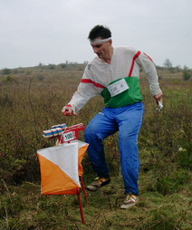
An orienteer at a control point
Image via Wikipedia

Put down your iphones and pick up your compasses – join a scavenger hunt with the Western PA Orienteering Club this Sunday.

Where: Deer Lakes Park, Russellton, PA

When: Sunday, October 4, 2009; sign-in 11 AM – 2 PM

What is Orienteering? Orienteering is a competitive form of land navigation. It is for all ages and degrees of fitness and skill, and all-weather. It provides the suspense and excitement of a treasure hunt. The object of orienteering is to locate control points by using a map and compass to navigate through the woods.

What to bring? All you will need to bring is a compass (if you do not have one, we can loan you one), and appropriate footwear to walk in the woods.

Event Details: The courses offered at Deer Lakes Park will include Cross Country courses for beginner and advanced beginner, intermediate and experienced orienteers. Cross country courses involve finding a series of control flags in a pre-specified sequence. Come early if you plan to do more than one course.

  • Sign In 11:00 am to 2:00 pm
  • Must Finish the course by 3:30 pm

Instruction for novices: Available on site

Cost: $4.00 per map (family or group can share one map if they wish)

Event Location: Deer Lakes Park, Russellton, PA. Anglers shelter off entrance #1 to the park. Look for red-and-white arrow signs. http://www.cosc.iup.edu/wpoc/f09deerlakes.htm

Questions: Contact Jim Wolfe at jlwolfe@atlanticbb.net

Check our website, www.wpoc.org for complete details and driving directions for this event and the entire WPOC schedule of events.

Continue reading