Category Archives: Outdoors

Prince Gallitzin State Park

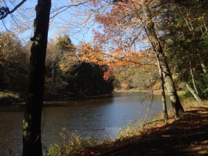
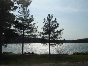
Lake at Prince Gallitzin (Photo by Andrew)

Prince Gallitzin State Park, located in Cambria County, is not the easiest state park to access, which lends it a remote charm. That said, when I visited last summer, the campground was rather crowded (though not overwhelmingly so), all of the best parking spots in the fishing areas were taken, and the lake was populated with a healthy number of boaters, so it’s no ghost town during the peak season.

Returning to the park more recently, in the off-season, the situation was rather different; boaters were now the exception, and aside from the marina, most of the parking lots were all but vacant. The beach was closed, of course, and there were but a handful of anglers.

There are two views of the lake that are worth making a special effort to visit; one is located off of SR 1026, and if you’re heading east, it will be located on the left. There are two entrances and they’re well-marked, but if you happen to miss it, the ranger station is just down the road, and you can turn around there. This first vista, called Mud Lick Overlook after the section of Glendale Lake it is nearest to, contains a pavilion that makes for a great inclusion in a photograph, if such structures are fitting to your artistic sensibilities.

The second vista, amusingly titled Headache Hill Overlook, can be accessed en route to the west end of the lake (more on this later, but the road is called Beaver Valley Road and marked with signs that indicate that it is a relatively minor section of the park, but don’t be fooled: the best trails are in the west area). From Beaver Valley Road, make a right at the four-way intersection onto Long Road and bear left at the hill up to the structure that looks like a water tower. The tower can be climbed via a set of stairs, and it offers what appears to be a view of two lakes, but it’s actually the same lake (the connecting canal is hidden from view).

The eastern section of the park is where the main beach is (there is a beach in the western section, but you have to be staying at the campground to use it, unless you want to walk a significant distance on a dirt trail in your swimming gear). It is also the site of a number of gentle, entertaining trails. To access this area, turn onto Buck Road from SR 1026 (don’t worry; it’s well marked). All of the beach parking lots are ultimately fairly close together, but the lot for Beach #3, at the end of Buck Road, is probably the “best,” in terms of design and lack of crowds. This lot is also where one would start on Turkey Ridge Trail or Huges Trail, which are worth your time. Also of interest is Lakeshore Trail; this trail begins directly below the parking lot for Beach #1, but if you’re parked at Beach #3, it’s silly to move your car. Instead, simply walk down to the beach and head south (with the lake on your right) until you reach the trail. The view is arguably better from the beach anyway, and you’re saving gasoline.

The western section of the park contained the trails I enjoyed the most. The best place to park would probably be at the Point Trailhead, but one can also use the visitor parking section of the campground (turn at the campground entrance and follow the signs). The Point Trail itself is a delightful hike that passes through a cool swamp and runs along Glendale Lake for a significant length. It’s about three miles long, but it’s also one of those trails that doesn’t seem that lengthy due to the sheer enjoyment of the views it provides. One can also hike the Campground Trail, which connects at both ends to the Point Trail; exploring the section that runs along the lake is definitely worth your while. This section of the Campground Trail will lead you to the western shore beach, as well as by the Camp Store, which might be useful if you need a quick snack.

Even if you’re not into fishing, stopping at some of the fishing areas is worth the time; the different perspectives of the lake are always a pleasure, and there are at least two that have unique features that might be of interest to photographers and general sightseers. The Beaver Valley Marina contains a cool little peninsula that seems to place you in the middle of the lake, and the Pickerel Pond area contains a neat little fishing pier and another bridge further back that permits one to construct a mini-walking loop. The trees in this area are also great for photographs.

Directions: Well, the bad news is that there really isn’t an easy way to access the park, and even from Pittsburgh there are two distinct routes to Prince Gallitzin. This map might be useful, but consulting a Pennsylvania map would definitely be advised. The route I took involved following Rt. 28 north to Kittanning and then following US-422 east, but from there, the optimal route gets somewhat complicated…a route that’s easier to summarize (but longer) involves making your way to Monroeville, following Rt. 22 east, and then taking Rt. 53 north (per the map provided earlier).

Pittsburgh Mini Climate Ride – April 23

The Climate Ride is a bike ride from New York to Washington, DC in May that raises money to support sustainable solutions and environmental causes.  There is also a Climate Ride in California in the fall.

Transition Pittsburgh, a newer group in Pittsburgh focused on community building and sustainable development, is organizing the Pittsburgh Mini Climate Ride.   This ride is a 15 mile bike ride around Pittsburgh which will stop at local businesses and nonprofits that are focused on sustainability.   The ride will raise funds for the national Climate Ride.

Pittsburgh Mini Climate Ride
April 23, 2011
Bike Ride 1-5pm
Happy Hour Party for riders and non riders – 5-8pm
Facebook Event Link –  http://www.facebook.com/event.php?eid=205860669431690

The Ride is a 15 mile loop starting and ending at OTB.  Suggested donation is $15/$20.  The tour will be stopping at the following places:

  • CCI
  • Bike PGH
  • Tree Pittsburgh
  • Grow Pittsburgh
  • East End Brewing Co
  • Transition PGH
  • and more!

The Happy Hour will also be at OTB and is free for riders and $5 for everyone else.

You can read more about the ride at BikePGH, thanks to East End Brewery for the heads up on this great event.

Enhanced by Zemanta

Trillium Trail & Salamander Park

Trillium Trail (Photo by Andrew)

The trails themselves might be officially dubbed “Xen’s Trail,” “Upper Trail,” and “Falls Trail,” but locals refer to the collective nature area off of Squaw Run Road as “Trillium Trail,” and indeed, maps recently posted at the site are headed with the moniker “Trillium Trail.” There are two parking lots available; both provide access to the ends of Xen’s Trail, so neither lot is inherently preferable; it all depends on how crowded they are (and apart from, say, the first few days of warm weather in March, the lots are rarely so crowded as to preclude finding a spot).

Xen’s Trail is the “main” trail, a level walk beneath a gentle hillside. The trail crosses a creek multiple times; this used to be more of a problem, particularly during rainy months, but recent redirections of the trail and new stepping stones placed in the creek have made this a relatively painless procedure. Be aware, though, that crossing will still be difficult when the creek is particularly high, and unfortunately, the stepping stones (particularly beneath the stairs across the street from the larger parking lot) do not offer optimal traction. This aside, Xen’s Trail is a very easy and relaxing trail.

Continue reading

Cook Forest

Clarion River at Cook Forest, as seen from River Trail (Photo by Andrew)

Although Cook Forest is definitely one of the better-known recreation areas in western Pennsylvania, it’s always good to remember those sorts of places and then actually make the effort to visit them; it’s too easy to take institutions for granted (a perfect example is the Allegheny County library system, but more on that in a future post).

The fire tower is probably the best-known sight at Cook Forest; off or Rt. 36, there is a one-way loop that leads to the parking area. The walk to the tower is not very long, and the tower can be climbed, offering a great view of the surrounding wilderness. An even more stunning view can be found at Seneca Point, which is in the same vicinity; a short trail off of the path that leads to the fire tower will take you to a massive boulder from which the Clarion River can be viewed.

More good news; even better sights of the river are possible via the aptly named River Trail. From the fire tower itself, simply follow the signs and blazes The trail will basically take you all the way down to the river and run along its length for a decent amount of time. Eventually, the trail will split; the River Trail heads back up the hill to ultimately connect with the one-way road you’ll be leaving on; because the trail doesn’t lead back to the starting point, you’ll have to walk on the road for a while, but because it’s in the wilderness and the speed limit is so low, it’s far more enjoyable than you’d think. If you’re not quite ready to head back to your vehicle, you can continue to walk along the river, via the Baker Trail (a portion of which also cuts through Crooked Creek). In either case, I highly recommend walking the River Trail if you’re up for it (note that the descent and ascent, while not steep, are relatively lengthy, though nothing that a Pittsburgher used to walking hilly streets would find too difficult).

The Sawmill Craft Center is, in my humble opinion, rather kitschy; the Black Bear Trail, which can be accessed via the same parking lot, is decent, but hardly a match for the River Trail. A far superior trail (actually, network of trails) can be found by the park office (also the site of many rental cabins). These trails are numbered and named, but beware; there are numerous intersections at which the map and posted signs do not coincide. I hope this doesn’t scare you off, because these trails really are worth checking out. I suggest starting with trail #7, which begins with a set of stone stairs; the trailhead is between the children’s fishing pond and the first of the cabins. Trail #7 is pretty much all uphill for its first half, but from there it’s basically flat, and for the most part, the rest of the trails are also flat, or else lead downhill (what else did you expect?!?).

From there on, it doesn’t really matter which trail(s) you decide to explore; they’re all pretty much the same, and all equally entertaining. The only other landmark you might wish to see is the swinging bridge, which connects trail #4 to trail #6; these two trails begin at the far end of the cabin area, and if you’re not up for a climb, it might be best to simply start with one of them, given that they’re relatively flat, easy walks.

Also in the area:

Depending on how much time you have, you might want to consider heading even further north, to the depths of the Allegheny National Forest. There is also another state park near Cook Forest, just outside of the boundaries of the Allegheny National Forest; called Clear Creek, it can be accessed off of Rt. 949.

Eat Pancakes for Tree Pittsburgh

Image courtesy of Tree Pittsburgh

On Sunday, March 6 from 10am to 2pm at the Double Wide Grill on the South Side you get all you can eat pancakes for $10 and your donation goes directly to benefit Tree Pittsburgh – an environmental non-profit organization dedicated to enhancing the City’s vitality by restoring and protecting City trees.  Why should you attend?  Well, pancakes are delicious (and there is a vegan option), you get free coffee and potatoes as well, tunes from Big Snow Big Thaw, and street trees are a critical element for a livable urban environment.  Are you one of those people that includes a link on your Facebook page every time Pittsburgh gets voted ‘most livable city’ (possibly including the comment ‘suck it, Portland’)?  Well street trees are a huge part of reducing our City’s pollution* and there is still a long way to go in improving our air quality.  Who knows?  Your $10 just might end up helping to promote Pittsburgh to most livable city in the world!

For more information on Pittsburgh’s urban forest, info on street tree plantings in your neighborhood, and to learn about becoming an official tree tender to help care for Pittsburgh’s trees visit the Tree Pittsburgh’s website!

RSVP for breakfast on Facebook!

*Leaves filter the air we breathe by removing dust and other particulates. Leaves absorb carbon dioxide and other pollutants from the air such as ozone, carbon monoxide, and sulfur dioxide.  In exchange, trees give off vital oxygen.